


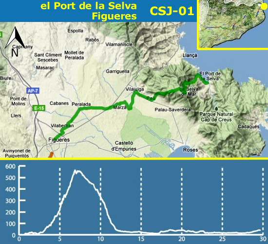
This is the first section of Way of Saint James. The distance is 30.5 km. It starts at El Port de la Selva, passes through Sant Pere de Rodes, where we recommend visit the monastery and enjoy the view, Pau; Vilajuïga, famous for its mineral waters; Marzà, Peralada, with its impressive castle and its stork nests; Vilabertran and Figueres.
This section is divided into two parts. The first part is about 13 km from El Port de la Selva to Pau, with a height of 527 meters, whose highest point is Sant Pere de Rodes. Of medium difficulty, must be done on foot and footwear. The second part, from Pau to Figueres, it's 17,5 km. It's flat and can be done on foot, by bicycle or by car. There are sections shared with vehicles. Keep attention between Vilabertran to Peralada. So be careful!
You can find car parks, fountains, bars and restaurants in urban areas (except Marzà) and Sant Pere de Rodes. There are picnic area at Mas Ventós (about cache CSJ 01-19) and Vilajuïga (cache CSJ 01-32). You should bring sunscreen and water, because there are no fountains in the way.
This section has 61 caches (1 regular with geoStamp, 5 smalls, 50 micros and 5 others).
You can do this section by foot, by bicycle or by car, 4x4 not necessary. We recommend that you park the vehicle at a good place that doesn't obstruct the circulation for find the caches.
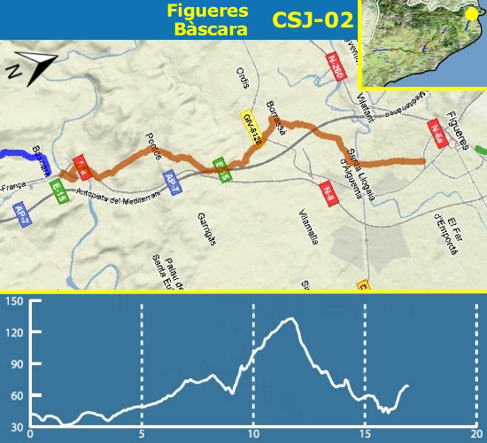
We start this way leaving Figueres and we go in the direction of Santa Llogaia d'Alguema. Since the cache CSJ-02-01 to CSJ-02-08 the route takes place at asphalt road, there isn't pedestrian phial. Be careful.
When we arrive at the rotunda which is at Santa Llogaia d'Alguema, we must take the ground way, it is situated at the right. The old Via Augusta takes us to Borrassà. This way isn't asphalt but you can do it with any vehicle. The way will bring us to the cache CSJ-02-13.
We enter at Borrassà's town and across it. In the town you can visit Sant Andreu de Borrassà's church, which dates of the XVII century, of the baroque's style.
Then we leave Borrassà to go towards Creixell, before arrive at the cache CSJ-02-16 it starts again the ground way. When we arrive at Creixell we could see the Santa María de Creixell's church of the XV century.
Since the cache CSJ-02-20 until the CSJ-02-28, the way isn't asphalt but after some meters (150 m) there is an asphalt road. Be careful.
We will follow the diversion in the direction of Pontós. This way will guide us from the cache CSJ-02-29 to the CSJ-02-32. When we arrive at Pontós we will find the Sant Martí's church of the XVIII century. The town tinned remains of a Roman dam.
When we come out of the town we will find a ground's way which brings us to the cache CSJ-02-38 and CSJ-02-39 (we recommend do this caches by foot or 4x4 vehicle because there is a small torrent). We are near Bàscara and we must across the N-II road under the bridge and follow the ground's way that bring us to the town.
According to the season we must be careful because we have to across the river to do the cache CSJ-02-43 and CSJ-02-44. If you can't across the river, you can do these caches by the other side. During Christmas time you could visit the living Nativity scene, which is very famous.
This section has 45 caches (1 regular with geoStamp, 3 smalls, 35 micros and 6 others. The section is 16,2 Km.
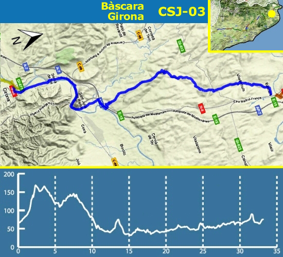
In this stage we leave the region of l'Alt Empordà, pass through the eastern part of el Pla de l'Estany and we will end up in el Gironès. The great Empordà writer Josep Pla named Terraprim these lands, the transition zone between the plain of l'Empordà and the most mountainous la Garrotxa.
Shortly after we started the stage we will enter in the municipality of Vilademuls, the largest in el Pla de l'Estany, with twelve towns. We will pass through the town that gives the name to the municipality, Vilademuls, where there is the Romanesque church (although it was reformed during the XVI century) of Sant Joan Baptista, the remains of the castle, especially a gateway, and a museum of rural life set in the rectory. If you wish, you can find the hiding GC30EYT.
We will continue to Terradelles (GC30F4A), site documented in 841, where stands the church of Sant Martí (XVIII century) and some civilian buildings.
The road continues towards Sant Esteve de Guialbes, with a church already documented in 1064 (was the old castle Guialbes, built in the mid-eleventh century by the Count of Barcelona, enemy of the Count of Besalú, who had built the castle Vilademuls). The present church was rebuilt in the sixteenth century. In the village you have two caches (GC28DBD and GC1TE64).
We continue to Sant Mer, a XIII century chapel rebuilt in 1627. Tradition says that Sant Mer, legendary founder of the monastery of Banyoles, moved here to live a hermit life. You also have a cache (GC19DE7).
After a steep climb we will reach the road that takes us to Medinyà, a place already mentioned in 1017, in a bull of Pope Benedict VIII, and in 1128 in the Llibre gran dels Feus. Near the Saint James' Way you can see the castle, which is documented in the eleventh century. In the fourteenth century was a Xammar family property; from the eighteenth century belongs to the Fonsdeviela family. Within the castle complex is the church of Sant Sadurní. Nearby you can find the cache GC25BRB. In 1389 was founded a hospital with its own chapel dedicated to St. James. Nothing remains of these buildings but the memory of its location, at number 20 on the street Pere Roure, where a plaque can be seen. You can find the cache GC30JEW.
Once you cross the road networks AP7 and A2 we will head to the Congost, following the river Ter and going under the Sants Metges mountain (at this summit you can admire the Castle of Sant Julià de Ramis, the Roman settlement Castellum Fractum -GC2BY7A – and the church of SantsMetges -GCR5RK-). This place, important and strategic crossing point from l'Empordà to el Gironès, is full of testimonies of human habitation from the earliest times: the Cau de les Goges, the Cova de les Goges (now disappeared), the Cova de Can Sant Vicenç and the site of Pedra Dreta.
We will arrive at Sarrià de Ter. The route continues through the district of Sarrià de Baix, following the Carrer Major, the former royal road from Girona to France. In this street there are good examples of modernist architecture, such as a Rafael Masó building, which formerly occupied the municipal schools. At the end of the street is the parish church Mare de Déu de la Misericòrdia. Although its construction began in 1800, the works did not end until 1925, because of the French War (War of Independence), during which the temple was occupied by French troops, first as a place of supply and then as a war hospital. You can look for the cache GC26D09.
We will cross the Ter river through the Pont de l'Aigua (destroyed by the Republican army during the retreat of 1939 and rebuilt by prisoners of war, veteran Republicans) and we will arrive to the Girona neighbourhood of Pont Major and finally to Pedret neighbourhood, where the section ends.
This section has 60 caches (1 regular with geoStamp, 1 smalls, 51 micros and 7 others). The section is 27,7 Km and you can be done on foot, by bicycle or by car.
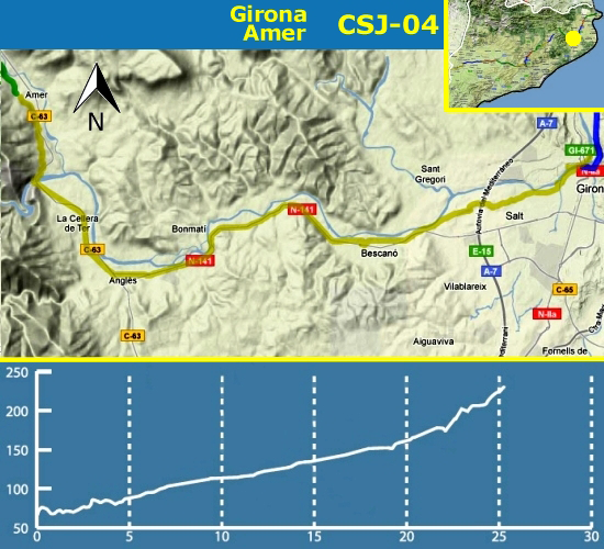
From Amer to Girona, we continue the Greenway Carrilet. This stretch of the route, well signposted, offers no possible loss. The climb is gradual, almost imperceptible. Cyclists will be a walk, pilgrims on foot will have to take it easy. The section has good coverage of both mobile and GPS, there should be no problem finding the caches and less with the help of the hints and spoilers. It is a very busy stretch and that leads to geoMuggles has many roaming the area, so you'll have more patience waiting for people to go than find the cache. This section has 55 caches (1 regular with geoStamp, 3 smalls, 43 micros and 8 others). The section is 22,8 Km and you can be done on foot and by bicycle.
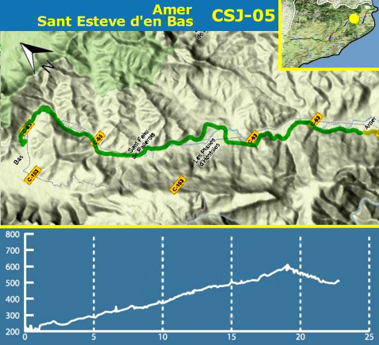
Another step along the Greenway Carrilet this section is well marked and gradual climb. Halfway is the town of Sant Feliu de Pallerols and at the end the Vall d'en Bas, very nice natural space. In general, the section has poor coverage. There are subsections dug into the hard rock and this has had poor accuracy in some caches, in these cases must rely on instinct geocacher, spoilers and hints. The direction of the section is Amer - Sant Esteve d'en Bas, in this sense the path climbs gently to a small decrease in the end. Check profile before choose the direction.
This section has 70 caches (1 regular with geoStamp, 6 smalls, 60 micros and 13 others. The section is 22 Km and you can be done on foot and by bicycle.
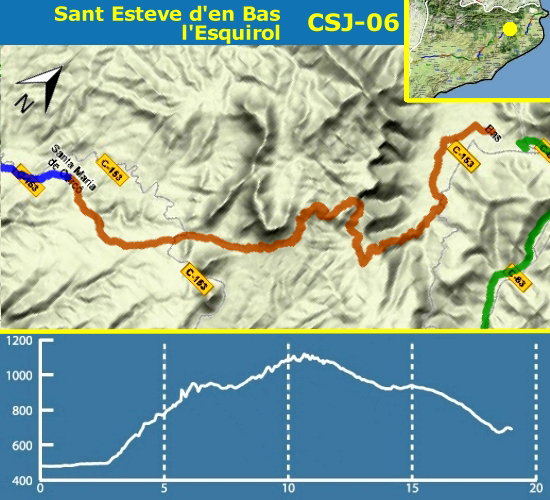
This section of the route, between forests of oaks, beeches and oaks, is one of the most beautiful of the whole route. Should be fit to cross the Marrades del Grau d'Olot, section of the Camí Ral de Vic a Olot.
This section has 55 caches (1 regular with geoStamp, 3 smalls, 46 micros and 5 others). The section is 19 Km and you can be done on foot, once passed the Marrades can use 4x4 car to reach before Cantonigròs.
The route passes through two villages, Els Hostalets d'en Bas (cache CSJ 06-06) and Cantonigròs (caches CSJ 06-46 and CSJ 06-47) where you can find restaurants and bars, as well as the origin and end of the section.
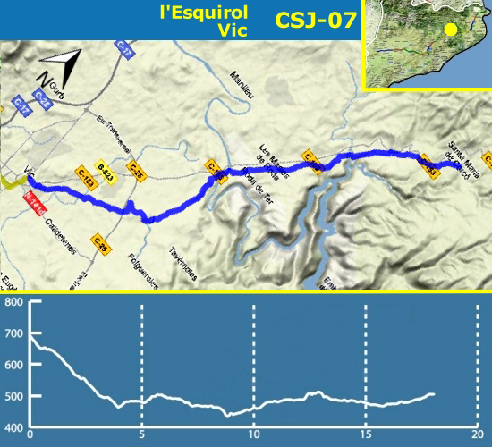
This is a section easy to walk and bike despite the constant ups and downs. Most of the stage is set in the woods near roads that serve as reference. You will access to Vic from Bruguer bridge, full of history. It couldn't be more real.
This section has 41 caches (1 regular with geoStamp, 2 smalls, 33 micros and 5 other). The section is 18 Km and you can be done on foot, by bicycle or by car.
This section passed through three major populations: l'Esquirol, Roda de Ter and Vic, these have different services; bars, restaurants, accommodations, fountains...
Should be taken into account, because the stretches in between will not find any source or bar.
Of interest are the landscapes of Riera de les Gorgues, just before arriving at Roda de Ter.
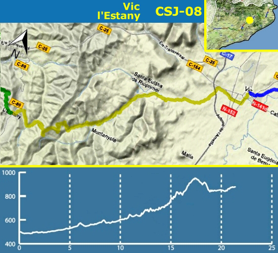
This stage began in the Plaza Mayor de Vic, we go side the Mèder river. Find an ice well, we can stop to visit.
We arrived at the village of Sentfores (or la Guixa) added to Vic. This section there are two no-drinking water sources. Not find sources in the whole way.
We continue to Santa Eulalia de Riuprimer, we did not enter. The road at all times have a slight rise, and from here get sharp increases, followed by 'camí ramader' until l'Estany, there are a hard descent.
This section has 62 caches (1 regular with geoStamp, 5 smalls, 51 micros and 5 others). The section is 21 Km and you can be done on foot and by bicycle to Santa Eulàlia de Riuprimer and the rest of the way also driving.
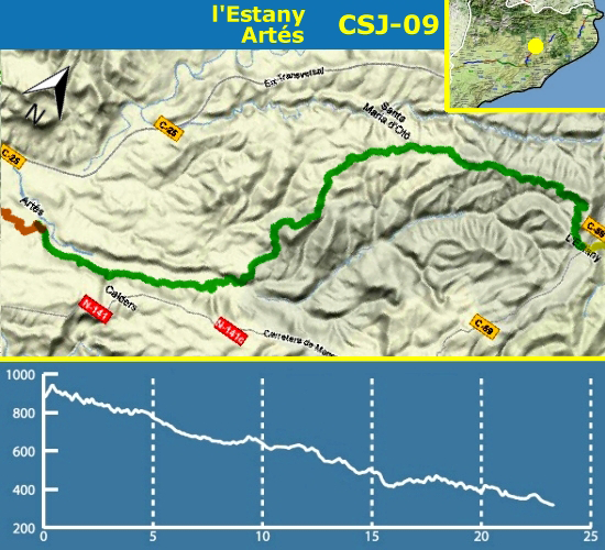
We began the section in l'Estany where we can visit the Romanesque monastery of Santa Maria de l'Estany.
We follow a gentle descent on a rural road, we passed near Santa Maria d'Oló, but not entered.
Cross two farms to get to the urbanization of Urbiossol where we follow a widest path to Artés.
This section has 80 caches (1 regular with geoStamp, 7 smalls, 62 micros and 10 others. The section is 23 Km and you can be done on foot, by bicycle or by car, on a rural road.
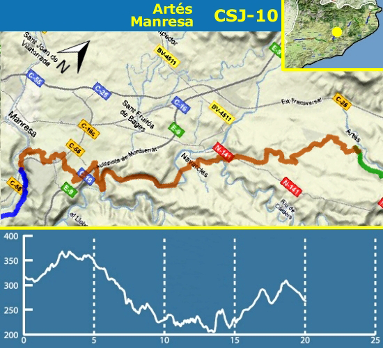
This section is an easy stage where almost the entire journey can be made by car. Part of the trail is recommended 4x4. It is a stretch without unevenness. The route through the villages: Artés, Navarcles, Sant Fruitós de Bages and Manresa.
This section has 95 caches (1 regular -one with geoStamp-, 7 smalls, 66 micros and 20 others. The section is 20 Km and you can be done by car, on foot or by bicycle.
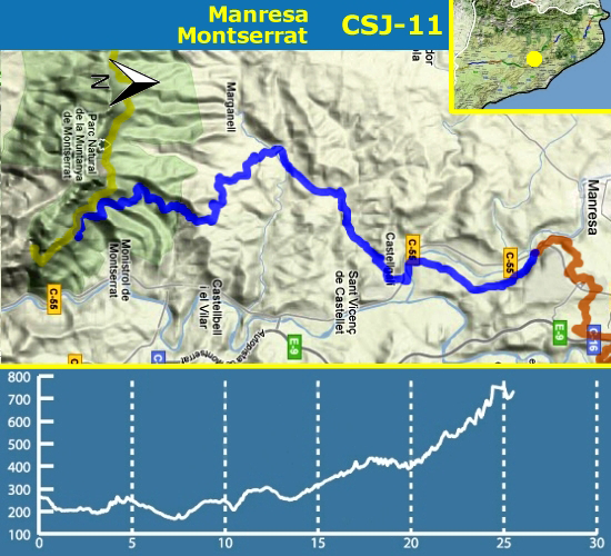
The main difficulty of this stage is finding the right way out of Manresa. You can use as reference part the old Roman road Manresa to Terrassa. In the distance there aren’t drops and going up to Montserrat is easier than expected.
This section has 52 caches (1 regular with geoStamp, 3 smalls, 44 micros and 4 others). The section is 25,5 Km and you can be done on foot, by bicycle or by jeep.
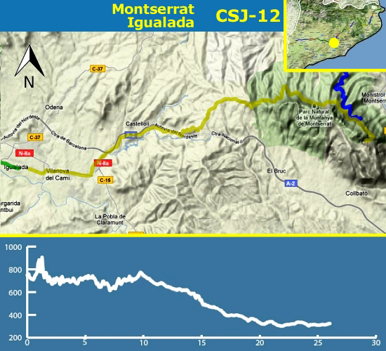
We can begin the journey towards Santa Cecilia, for Els Degotalls or Collbató, by way of Les Bateries. The route combines sections paved with forest tracks and moves from the urban bustle quiet Montserrat Igualada.
It must be especially careful at this stage will not find any fountain of public domain but they may stop for take a drink in the refuge of Santa Cecilia, Castellolí or finally in Igualada.
This section has 80 caches (1 regular with geoStamp, 7 smalls, 70 micros and 2 others). The section is 25 Km and you can be done on foot and by bicycle.
This section consists of 85 caches (1 regular geoStamp, 6 small, 65 micro and 13 other size). The section has a total of 37,7 Km and can be done by foot, on bicycle or by car.
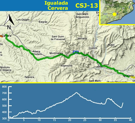
This is one of the longest stages of the Way of Saint James in Catalonia if the pilgrim does not decide to divide it in two days. Almost the entire route pass by rural roads have been paved. In the rise to La Panadella, the old route N-II, nowadays without traffic, there is a stretch of 4 km between Porquerisses La Panadella that must to be walked by the left shoulder of the road. It is not dangerous, but it is recommended to observe minimal rules of caution, as wear reflective clothing or to carry signals that indicate our position to the few vehicles circulating.
It is certainly a stage suitable for cycling, not only due to the outstanding softness, but also due to a recently released track cycling in perfect conditions, with a length of 11.5 km, starting from Sant Genís up to Santa Maria del Camí. Only a strong slope (with ramps near 10%) a kilometer in length, can make less accustomed to having to set foot on the floor. The whole route is very suitable for walking, and motor vehicle can do the entire route, but it's not recommended for crossing Igualada (caches CSJ 13-01 to CSJ 13-04), or to stretch Porquerisses-The Panadella (caches CSJ 13-45 to CSJ 13-54).
This stage takes place in rural landscapes of high beauty, especially in spring when the fields, dotted with forests typically Mediterranean, the undulations of the land stained a bright green. Once left Igualada, on its way to Cervera, the stage cross several villages: Sant Genís, Jorba, La Panadella, Els Hostalets i Sant Antolí, and Sant Pere dels Arquells. It is in urban areas where you can find remnants of the Way of Saint James, as the church of Santa Maria del Camí, o de Santiago, or Sant Jaume Sesoliveres, a little church outside of Igualada.
If even Cervera has opted for the GR-171 instead of following the road N-II, which continues to ride like Tàrrega is marked the chromaticism changing grain crops. The Way of Saint James, nestled in the valley of the river Ondara, it offers wide horizons but agricultural landscapes of great beauty.
The section has good coverage of both mobil and GPS, there should be no problem finding the caches and less with the help of the tracks and photos. For those who want to do it by bike or on foot, take care with the vehicles that can be found on the road.
This section has 55 caches (1 regular with geoStamp, 4 smalls, 39 micros and 11 others. The section is 26 Km and you can be done on foot, by bicycle or by car.
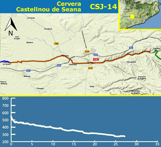
Cross Lleida's lands is not a thing anyone can say he has done, surely it is not easy despite the flat terrain. The landscape passes through orchards watered by the Canal d'Urgell to reach the city of Lleida.
This section has 72 caches (1 regular with geoStamp, 5 smalls, 45 micros and 21 others). The section is 28,9 Km and you can be done by car, on foot and by bicycle.
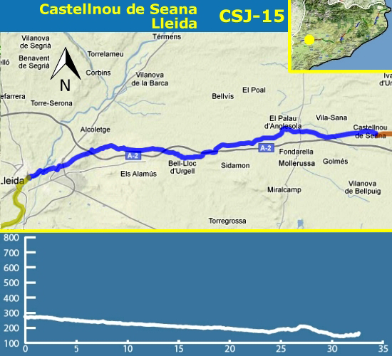
The route passes through two villages, Palau d'Anglesola (cache CSJ 15-21) and Bell-lloc (cache CSJ 15-45) where you can find restaurants and bars, as well as the origin and end of the section. The rest of the route passes through fields of fruit without fountains.
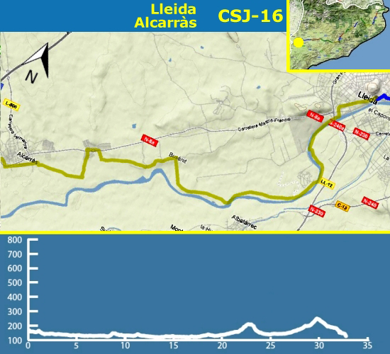
The beginning of the last stage of the Way of Saint James Way in Catalunya by the Riu Segre, reconverted to Greenway till Butsènit is nice to make even the hottest days, because it is in the shadow. From Butsènit to Alcarràs there are asphalt and agricultural paths between fruit fields. On hot days should be careful with the sun and dust.
This section has 33 caches (1 regular with geoStamp, 1 small, 24 micros and 7 others. The section is 12,7 Km and you can be done on foot, by bicycle or by car. If you choose drive, you must know that there is a discontinuity between caches CSJ 16-19 and CSJ 16-20. You should go to the main road and re-enter the same side two entries in the section direction.