


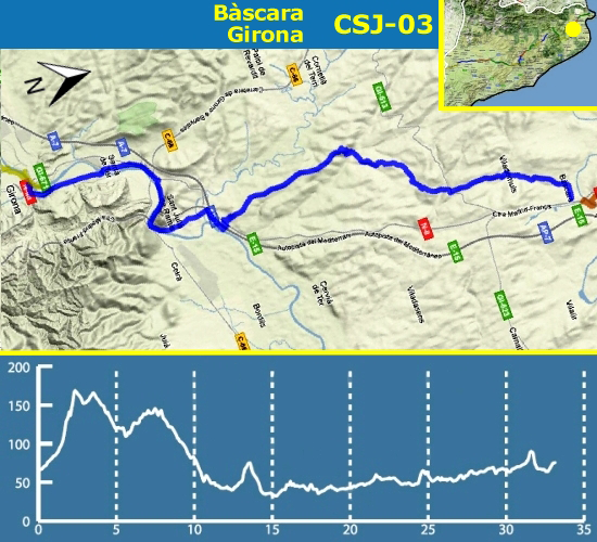
In this stage we leave the region of l'Alt Empordà, pass through the eastern part of el Pla de l'Estany and we will end up in el Gironès. The great Empordà writer Josep Pla named Terraprim these lands, the transition zone between the plain of l'Empordà and the most mountainous la Garrotxa.
Shortly after we started the stage we will enter in the municipality of Vilademuls, the largest in el Pla de l'Estany, with twelve towns. We will pass through the town that gives the name to the municipality, Vilademuls, where there is the Romanesque church (although it was reformed during the XVI century) of Sant Joan Baptista, the remains of the castle, especially a gateway, and a museum of rural life set in the rectory. If you wish, you can find the hiding GC30EYT.
We will continue to Terradelles (GC30F4A), site documented in 841, where stands the church of Sant Martí (XVIII century) and some civilian buildings.
The road continues towards Sant Esteve de Guialbes, with a church already documented in 1064 (was the old castle Guialbes, built in the mid-eleventh century by the Count of Barcelona, enemy of the Count of Besalú, who had built the castle Vilademuls). The present church was rebuilt in the sixteenth century. In the village you have two caches (GC28DBD and GC1TE64).
We continue to Sant Mer, a XIII century chapel rebuilt in 1627. Tradition says that Sant Mer, legendary founder of the monastery of Banyoles, moved here to live a hermit life. You also have a cache (GC19DE7).
After a steep climb we will reach the road that takes us to Medinyà, a place already mentioned in 1017, in a bull of Pope Benedict VIII, and in 1128 in the Llibre gran dels Feus. Near the Saint James' Way you can see the castle, which is documented in the eleventh century. In the fourteenth century was a Xammar family property; from the eighteenth century belongs to the Fonsdeviela family. Within the castle complex is the church of Sant Sadurní. Nearby you can find the cache GC25BRB. In 1389 was founded a hospital with its own chapel dedicated to St. James. Nothing remains of these buildings but the memory of its location, at number 20 on the street Pere Roure, where a plaque can be seen. You can find the cache GC30JEW.
Once you cross the road networks AP7 and A2 we will head to the Congost, following the river Ter and going under the Sants Metges mountain (at this summit you can admire the Castle of Sant Julià de Ramis, the Roman settlement Castellum Fractum -GC2BY7A – and the church of SantsMetges -GCR5RK-). This place, important and strategic crossing point from l'Empordà to el Gironès, is full of testimonies of human habitation from the earliest times: the Cau de les Goges, the Cova de les Goges (now disappeared), the Cova de Can Sant Vicenç and the site of Pedra Dreta.
We will arrive at Sarrià de Ter. The route continues through the district of Sarrià de Baix, following the Carrer Major, the former royal road from Girona to France. In this street there are good examples of modernist architecture, such as a Rafael Masó building, which formerly occupied the municipal schools. At the end of the street is the parish church Mare de Déu de la Misericòrdia. Although its construction began in 1800, the works did not end until 1925, because of the French War (War of Independence), during which the temple was occupied by French troops, first as a place of supply and then as a war hospital. You can look for the cache GC26D09.
We will cross the Ter river through the Pont de l'Aigua (destroyed by the Republican army during the retreat of 1939 and rebuilt by prisoners of war, veteran Republicans) and we will arrive to the Girona neighbourhood of Pont Major and finally to Pedret neighbourhood, where the section ends.
This section has 60 caches (1 regular with geoStamp, 1 smalls, 51 micros and 7 others). The section is 27,7 Km and you can be done on foot, by bicycle or by car.